There have been some reports that Pokemon GO’s popularity has started to shrink, but that shouldn’t come as an issue for the app developer, Niantic Labs, which still has millions of people running around cities chasing Pokemon characters. Now Google Maps offers these users the option to retrace their steps.
Google has just updated its Maps application with a feature that could come in handy to Pokemon GO players, as Ubergizmo reports. The new feature would allow Pokemon GO players to see the places where they’ve spotted and caught Pokemon, as well as the time when that occurred.
The information could come in handy if players wish to retrace their steps and share details with friends in the Pokemon GO community. Unfortunately, the new update from Google won’t help any other users since it’s aimed exclusively at people playing the game developed by Niantic Labs.
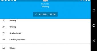
The feature is found under the Timeline section, in the menu at the side of the screen. Users simply need to enable their location services and then check the Timeline section in Google Maps.
There’s an option there called Catching Pokemon, right below the options for running or cycling. Users would also need to have Pokemon GO installed on their smartphones for this option to work.
The Timeline section shows users all the places they have been to, the time and a map with their route. It only works if location services are enabled, and the data can be later edited.

 14 DAY TRIAL //